The Flat Fire, burning approximately two miles northeast of Sisters, Oregon, is estimated at 23,380 acres and is 13% contained. Acreage reflects the most current infrared (IR) flight.
High temperatures and shifting winds are keeping crews alert, but thanks to the hard work and dedication of firefighters over the past several days, significant progress has been made in securing homes and reinforcing control lines. Downgraded evacuation levels have allowed residents to return home, a reflection of careful, collaborative efforts to ensure safe re-entry. Resources are still fully engaged in protection efforts, but the outlook remains positive.
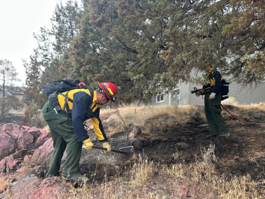
Overnight Thursday, wildland resources throughout the fire focused on methodical identification of potential hot spots, known as gridding, up to 300 feet from control lines in some areas. Structural crews continued to provide 24-hour protection to homes within the fire area.
Friday, wildland and structure resources remain in position for another round of challenging weather. Crews along the south and southeast perimeter will continue to hold established control lines amid gusty afternoon winds from the north-northwest. Along the western perimeter, structural task forces will monitor for hot spots near homes in the area, while wildland personnel continue mop-up downslope from the canyon rim. Aerial resources will provide eyes in the sky for wildland and structural crews below, identifying opportunities for targeted mop-up efforts.
In the north and northwestern fire areas, crews are beginning repair efforts, which aim to mitigate adverse effects to resources and the natural environment caused by suppression activities.
Teams are staying focused and flexible, adjusting to today’s weather while maintaining strong defensive positions around homes and neighborhoods. As containment increases and the threat to structures is reducing, Oregon State Fire Marshal will begin to send resources home. This will allow engines and personnel from fire departments all around Oregon to return to their communities, while ensuring adequate structural protection remains on the fire. Crews remain committed to this incident and to returning all community members to their homes safely.
Firefighter Safety: As weekend traffic increases and more residents return to affected communities, we ask everyone to remain mindful that fire crews are still working in the area. Please drive carefully, watch for firefighting equipment on the roads, and allow crews space to do their jobs safely. If your weekend plans take you outside, please be aware of the fire risks and recreate safely. Hot temperatures, low humidity, and gusty wind conditions persist in the area, naturally increasing fire risk and contributing to potential fire growth; help prevent the next wildfire by following all local regulations:
Oregon Dept. of Forestry: https://gisapps.odf.oregon.gov/firerestrictions/PFR.html
Deschutes National Forest: https://www.fs.usda.gov/…/info/public-use-restrictions
Ochoco National Forest and Crooked River National Grasslands: https://www.fs.usda.gov/r06/ochoco/alerts
Oregon/Washington BLM: https://www.blm.gov/orwafire
Evacuations: Evacuations are managed by the Deschutes County Sheriff’s Office and the Jefferson County Sheriff’s Office.
Level 1 and 2 evacuations remain in effect under the direction of the Deschutes County Sheriff’s Office and the Jefferson County Sheriff’s Office. Follow their Facebook pages for the latest information and updates. They can also be reached by phone: Deschutes County Sheriff’s Office at (541) 388-6655, and Jefferson County Sheriff’s Office (541) 475-6520.
A 24-hour evacuation shelter has been set up by the Red Cross at Highland Baptist Church located at: 3100 SW Highland Ave, Redmond, OR. Jefferson County Fairgrounds in Madras and Kerley Horse Center in Powell Butte are available for large animals.
Local Area Closures: To help fire operations and firefighter safety, the Bureau of Land Management and U.S. Forest Service ask that people stay out of the fire area.
The BLM has implemented closures, which can be found under the Prineville tab on the following page: https://www.blm.gov/…/oregon-washington/fire-restrictions.
The U.S. Forest Service has implemented closures, which can be found on the following page: https://www.fs.usda.gov/r06/deschutes/alerts
As a reminder, drone use near fires is both illegal and extremely dangerous to pilots working on incidents. If you fly, we can’t. FAA Temporary Flight Restrictions are in place for the fire area. All illegal drone use will be reported to law enforcement.
Smoke Report: The current smoke outlook for Central Oregon can be found on the following page: https://outlooks.wildlandfiresmoke.net/outlook/6436a95d?